Austin’s on the Wrong Side of the 100th Meridian
The invisible line that divides the arid western part of the country from the wetter eastern half is on the move, and that has important implications for the Texas capital.

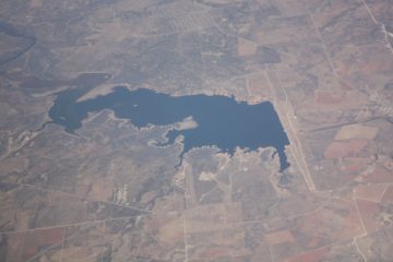
Meet Robert Lee. Not the Confederate general, the town. Robert Lee, Texas is a ranching community of 1,025 that lost its only source of water to the second-worst drought in recorded state history. By August 2011, Lake E.V. Spence, a praying-mantis-shaped, man-made reservoir once revered for its striped bass fishing, had all but dried up. It had been eight months since rain had fallen in the watershed, and as drought gripped the town tighter and tighter, owners deserted their high-priced but now-useless lakeside properties; ranchers sold off their herds; and town leaders scrambled to build a $1 million pipeline to bring in water. “When the rains slowed off in April and May, we kept saying, ‘Hang on. It’s coming, it’s coming.’ But it never did,” rancher Lee Hortenstein told the Houston Chronicle at the time.
Eventually, the rain did come, filling in the cracks of Spence’s clay bed and partially replenishing other Texas reservoirs strained by the years-long dry spell. But the drought shouldn’t soon be forgotten for a couple reasons, experts say. One is because climate change stands to exacerbate drought throughout the state — just this year, Amarillo went four months without a single drop of rainfall, a record rainless streak. Lubbock set two record high temperatures just this month.

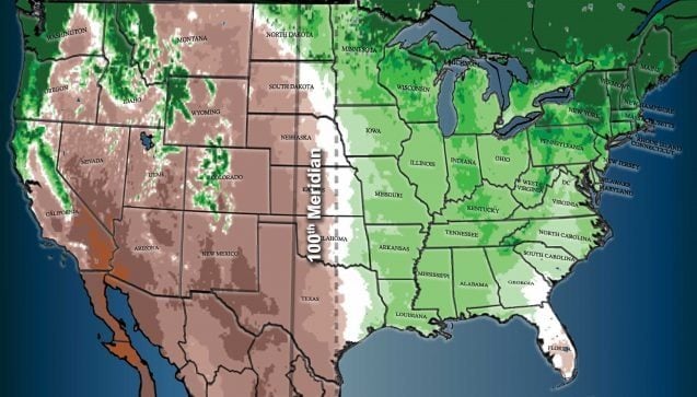
Both towns (along with Robert Lee) sit west of the 100th meridian, an invisible, north-south line that bisects the continent. In Texas, the 100th meridian cuts down the right-hand side of the Panhandle, through Childress, down to Abilene and past Laredo before pushing south into Mexico. Areas to its west tend to be warmer and drier, while areas to the east are generally cooler and wetter. The line is also thought to demarcate a cultural, political, agricultural and social boundary in the United States.
In March, Columbia University researchers made a bombshell discovery: The 100th meridian is on the move. Not the longitude itself, but the thing that represents. In other words, the 100th meridian — in the sense of a dividing line between the western and eastern halves of the country — is now closer to the 98th meridian.
That includes the fastest-growing part of the state: the Austin-Round Rock metro area, whose population is projected to swell by 83 percent to 3.78 million by 2046. All those people will need water, a resource that likely will be less available in the city’s warmer, drier future, said State Climatologist John Nielsen-Gammon. “As conditions become drier, reservoirs in Central Texas that had been reliably replenished at the end of a drought will start to see circumstances where the drought is over but the reservoir still isn’t full,” he said. “At that point it’s not really a drought anymore. It’s a permanent state of reduced water availability.”
The east/west divide associated with the 100th meridian was first identified in 1878 by geologist, adventurer and all-around badass John Wesley Powell, who, along with being a brilliant scientific mind, lost an arm in the Civil War before becoming one of the first Anglos to explore the Grand Canyon.

Powell urged lawmakers to dissuade settlers from living west of it because of the scarcity of drinking water. (Spoiler: They didn’t listen.) In the Columbia study, scientists not only confirmed the meridian’s existence — they also found that it has moved approximately 70 miles east. That’s a problem for Austin, which is now west of the line for the first time. For reference, the meridian’s shift is equivalent to moving from Mineral Wells to Arlington, or from Lampasas to Temple.
“What we experienced here in 2011, which was historic in terms of how intense it was, may just be a taste of things to come in the future,” said Jay Banner, a University of Texas at Austin geology professor who is researching the implications of the meridian moving. The 2011 drought illustrated that Austin’s Highland Lakes, which supply most of the city’s drinking water, aren’t immune to drought. And in 2015, water levels at lakes Travis and Buchanan dropped to 717,000 acre-feet, about 36 percent of their capacity. Inflow from the Colorado River was well below average at the lakes in January through April this year.
“[The 2011 drought], which was historic in terms of how intense it was, may just be a taste of things to come in the future.”
The Lower Colorado River Authority, or LCRA, which controls the Highland Lakes, uses the historic 1950s drought as its “drought of record.” The idea is that water managers make conservation plans with the worst-case scenario in mind so that they’ll never be caught off-guard.
But a study by NASA, Columbia University and Cornell University researchers found that the 1950s drought pales in comparison to “megadroughts” that ravaged the American Southwest for decades at a time during the 12th century. What’s more, an atmospheric researcher at Cornell University who participated in that study has predicted that there’s a 70 to 99 percent chance that another megadrought will strike Texas and other southwestern states this century if greenhouse gases continue to be emitted at their current rate.
Banner said the 20th-century droughts “are the ones that are hard in our rearview mirror, but if we think about it, they were relatively short compared to those megadroughts of the past. I think we should be concerned.”
I asked Clara Tuma, a spokesperson for the the LCRA, if the shifting meridian and increased drought risk will prompt the agency to manage water differently in the future. Tuma said the agency “does not have any comment on the veracity of any theories concerning a possible shift in the 100th meridian,” and that the river authority “will continue to preserve and protect the water supply, as it always has, in a region that experiences weather extremes.”


